
Editor's note: Retired Springfield meteorologist Drew Albert offers a series of monthly columns on weather trends in the Ozarks. For more on planning for severe storms, see our Daily Citizen series on tornado safety.
May is a month of stark contrasts where weather is concerned. I will say up front that as an outdoor enthusiast, April and May are my favorite months.
Temperatures are usually comfortable. Yes, it rains more often, but longer daylight hours allow the puddles and mud to dry more quickly. As a kid, May was my favorite month. School was nearly over, and baseball season was in full gear with lots to go.
But May weather has another side we in the Ozarks are all too familiar with. Severe thunderstorms and tornado chances reach their peak in May. The Hauxeda did a comprehensive look at Springfield tornado shelters in 2022, and it is recommended reading. Again, having your own severe weather safety plan at home, work, or the outdoors can help keep you safe ahead of the weather.

Cell phones can relay National Weather Service tornado warnings through the Wireless Emergency Alert (WEA) system. Survivors of the recent Bollinger County, Missouri nighttime tornado credited mobile phone alerts for allowing them to take cover before the tornado hit.
Squall lines and derechos
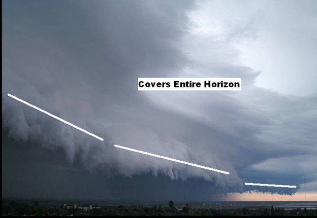
As we head into late Spring and early summer, storms known as squall lines usually occur more frequently. Squall lines are common across the United States east of the Rockies, especially during the spring and early summer. A “bow echo” or “bowing line segment” is an arched/bowed-out line of thunderstorms, sometimes embedded within a squall line, and is associated with damaging wind potential. On radar, as you might guess, these bow echoes appear arched in a bow or curved shape.
In general, the highest wind gusts with a squall line are near the leading edges of the storms. Sometimes the winds or “storm outflow” may precede heavy rain. “Worst is first” is a common phrase at storm spotter classes that describes when the strongest winds occur relative to the arrival of the rain.
A cloud formation called a shelf cloud is a low cloud that represents the updraft and downdraft boundary of a squall line. Gusty winds from the storms will begin as the shelf cloud passes overhead.
The largest and most damaging lines of storms classified as derechos increase in frequency over the U.S. in May and continue into the summer. Few people outside of the meteorological profession had ever heard this term, and many still haven’t. If you were around the Ozarks on May 8, 2009, you may very well know what the term “derecho” means.
A derecho (pronounced “deh-REY-cho” in English) is a widespread, long-lived windstorm. Derechos are associated with bands of rapidly moving showers or thunderstorms variously known as bow echoes, squall lines, or quasi-linear convective systems (QLCS).
The National Weather Service (NWS) Storm Prediction Center mentions a specific criterion that must be met before a system can be classified as a derecho:
“If the swath of wind damage extends at least 400 miles (about 650 kilometers), is at least 60 miles (about 100 km) wide, includes wind gusts of at least 58 mph (93 km/h) along most of its length, and includes several, well-separated 75 mph (121 km/h) or greater gusts, the event may be classified as a derecho. The derecho-producing convective system also should contain certain radar-observed storm features such as bow echoes and rear-inflow jets”
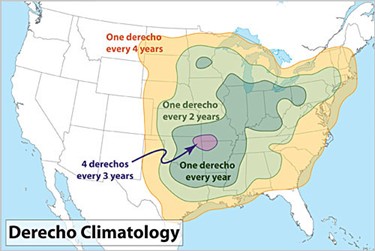
The peak season for derechos in the United States is May to July, when almost two-thirds of them occur, on average. The Ozarks region sees these weather systems, on average, once or twice a year.
While derechos and smaller squall lines and bow echoes are best known to produce straight-line wind damage, they can also produce tornadoes. Tornadoes associated with lines of storms, commonly referred to by meteorologists as “QLCS tornadoes”, can occur near or just behind the leading edge of a line of storms. These tornadoes are generally short-lived and sometimes go unseen by meteorologists at some distance from the radar since the circulation associated with them often occurs at lower altitudes below the radar beam. Under some conditions, stronger, longer-lived tornadoes can also occur.
There are some excellent technical sources if you want to learn about derechos and bow echoes:
- Storm Prediction Center (SPC): About Derechos
- National Weather Service Louisville, Kentucky: Squall Line/Bow Echo/QLCS (weather.gov)
A look back at the May 8, 2009 ‘Super Derecho‘
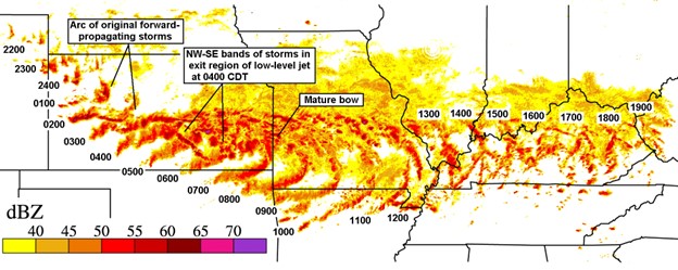
For early May, it was extremely warm and humid during the overnight hours prior to sunrise on Friday, May 8, 2009. A nearly stationary west-to-east frontal boundary stretched from Oklahoma and southeast Kansas into southern Missouri with a very unstable air mass running along and south of the front. Storms organized over western and central Kansas during the predawn hours as a disturbance moved eastward. There was a high expectation of some degree of active severe weather for the Missouri Ozarks during the Friday morning hours. However, the intensity of what occurred was not expected.
As warm, moist air was drawn northward, the developing storms over Kansas developed into an intense squall line/derecho as the system moved eastward.
When storms moved into Joplin shortly after 7 a.m., winds gusted from 60-90 mph. Damage to trees, structures, business signs, and power poles was widespread.
The most significant damage occurred from winds knocking over a television tower at KSN TV on the west side of Joplin. The tower fell into portions of the studio building and caused the station to be off air for several weeks. Part of the tower also fell on a nearby residence, destroying a vehicle and damaging a house. Thousands of Jasper County residents were left with roof damage and left without power for several days.
Storms shifted east into the Springfield area by around 8 a.m. with continued fury. In addition to the wind gusts up to 90 mph along the leading edge of the storms, a small-scale circulation known as a mesoscale convective vortex (MCV) developed, which aided in producing additional intense storm activity including strong winds, large hail, and tornadoes. This feature prolonged the period of damaging winds by an hour in some cases. Like the Joplin area, damage to homes was common, and widespread power outages occurred.
May weather by the numbers
| Temperature | May 1 | May 15 | May 31 |
| Normal High (Degrees F) | 72 | 76 | 81 |
| Normal Low (Degrees F) | 51 | 55 | 60 |
| May Precipitation (Inches) | Highest | Lowest | 30-Year Average |
| 16.15 (1943) | 0.34 (1911) | 5.56 |
- May is generally the wettest month in Springfield. It has the highest monthly average rainfall.
- The last time it snowed in May was in 2013, when 1.4 inches fell. The high was 36 degrees and the low was 32 degrees that day. The highest snowfall in May occurred on May 2, 1929, with 6.1 inches.
- The highest daily rainfall for May is 4.29 inches, set May 22, 2020 and May 23, 2019.
- The highest all-time May temperature in Springfield is 95 degrees on May 31, 1954. The lowest temperature was 29 degrees on May 6, 1944.