
With the recent quiet weather we have been having in the Springfield area, with no warnings from the local National Weather Service office since Sept. 24, it is easy to forget how severe storms can happen any month of the year in the Missouri Ozarks.
Traditionally, the spring and early summer months from April to July usually come to mind when you think of organized or tornadic severe weather in Missouri.
However, when first moving here I was taught about the “mini severe weather season,” which can sometimes occur in November, maybe stretching into early December. Having seen some impressive winter severe outbreaks in January (especially in 2008), the late autumn severe storm season may be somewhat nebulous as to when it ends. Suffice it to say, you can get severe weather and tornadoes late in the year in the Springfield area.
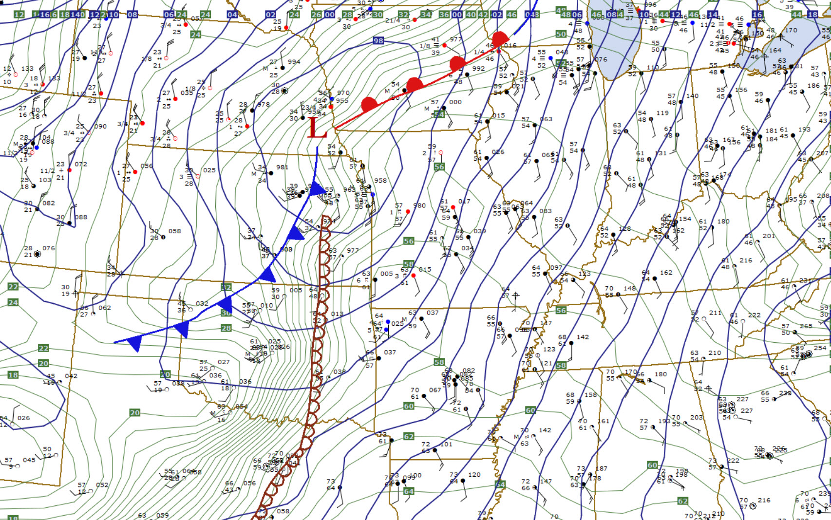
The general setup for severe storms in November and December will almost always involve a strong mid-latitude storm system with a large contrast in temperature with warm and moist air from the Gulf of Mexico ahead of the storm and unseasonably cold Canadian or Arctic air advancing south.
I picked out some past notable November-December severe weather events for this article. The list won’t hit all the events, of course.
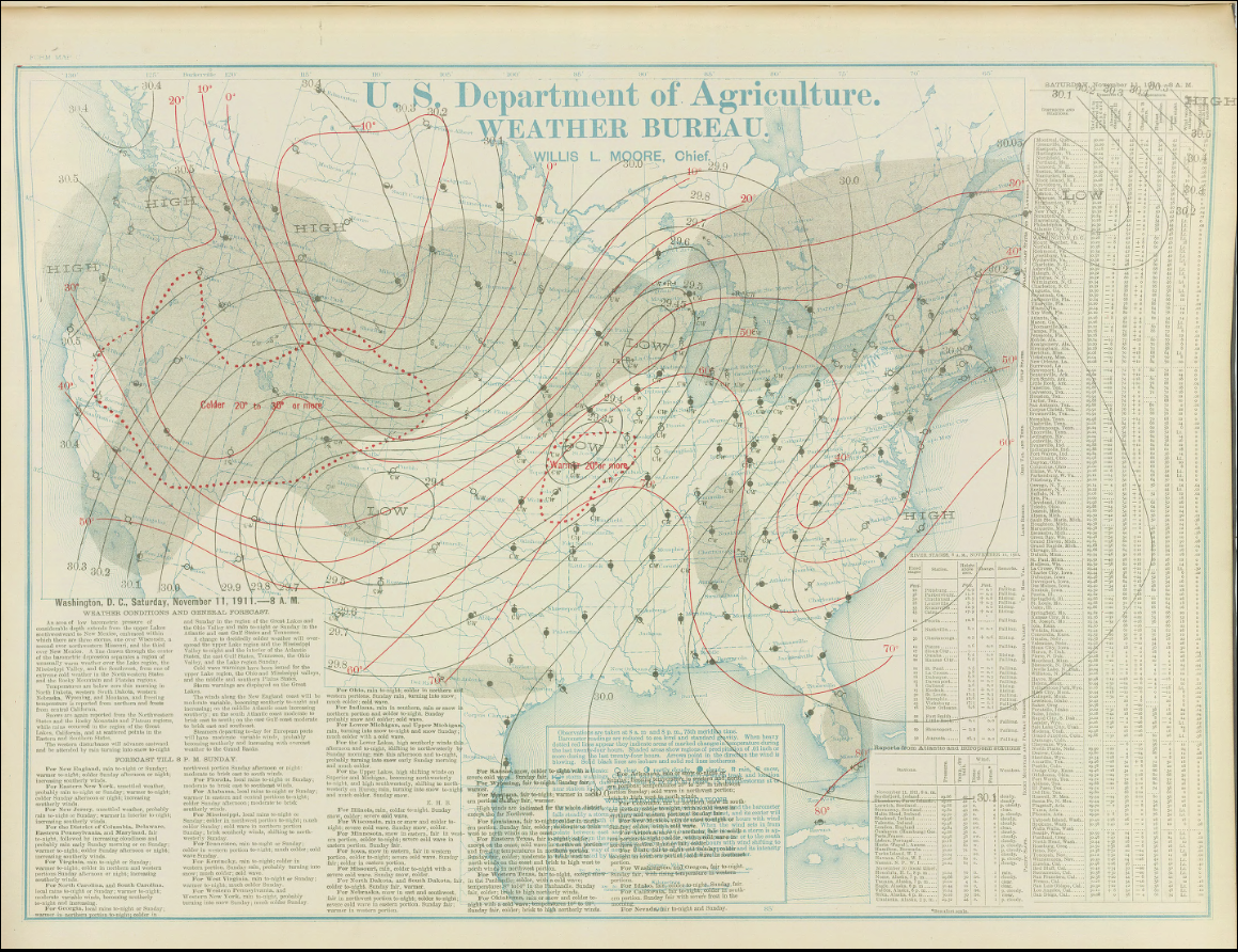
‘The Great Blue Norther’ Nov. 11, 1911
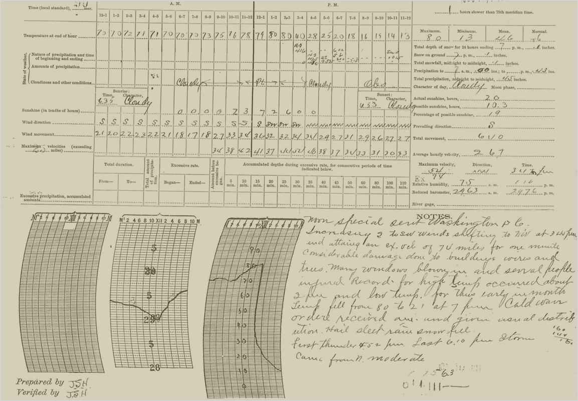
The term “Superstorm” (or add your favorite media-grabbing headline here…) gets thrown around rightly or wrongly. In the 20th century, the 11/11/1911 storm is still famous in meteorological circles today, and not just because of the date. When you set a record high temperature (80 degrees Fahrenheit) and record low temperature (13 degrees) for the date in Springfield on the same day, you might just have a real Superstorm on your hands.
Severe winds damaged buildings causing injuries in Springfield. Freezing rain and snow eventually occurred in the cold air behind the front.
A 1911 Encyclopedia Britannica article describes the term “Norther” as, “…a winter wind accompanying the “cold wave” that follows the passage of a cyclone across the United States of America. A warm S.E. or S.W. wind on the east of such a cyclone materially slackens or entirely dies away, and is followed, often suddenly, by the piercingly cold norther. The passage of a cyclone across America is usually from W. to E., and the cyclonic system of circulation would produce these results; but as the North American cyclones usually originate east of the Rocky Mountains, the warm air drawn from the Gulf of Mexico is not only followed by the cold air drawn from the Arctic regions but the body of cold air slides down the eastern slopes of the Rockies and advances as a solid wedge (the “cold wave”) under the cyclone itself.
“Uncomfortably warm in the lightest clothing,” a traveler upon the prairies of Texas may become “uncomfortably cold before he can wrap his blanket around him” (W. Ferrel, A Popular Treatise on the Winds). The temperature may fall 50° F. in twenty-four hours”.
This 1911 storm also produced widespread severe weather and tornadoes over the Midwest followed by snow and blizzard conditions in some areas. More here from the National Weather Service. A web search for this storm will yield a variety of articles as well.

Billings-Republic-Springfield-Buffalo F2 Tornado Dec. 14, 1971
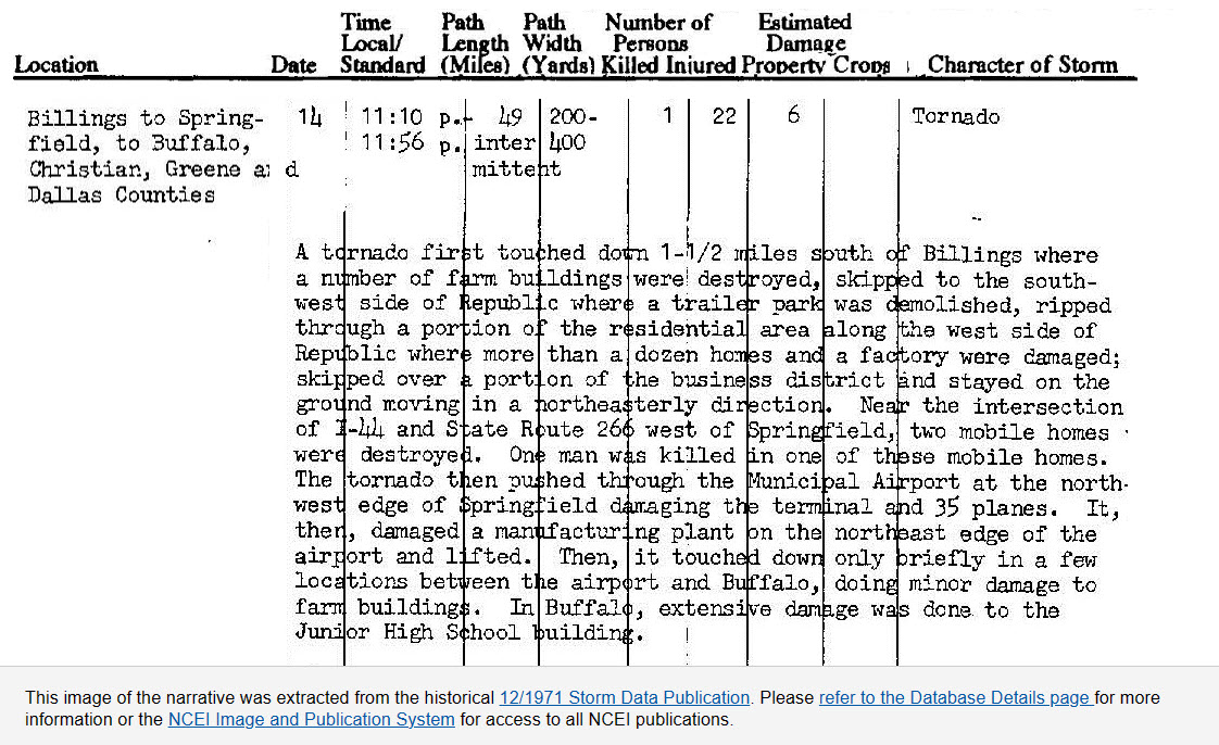
From the National Weather Service Springfield’s website: “On December 14, 1971, a tornado which began to the immediate southwest of Republic, cut a swath through the city of Republic, and moved directly northeast to pass over (National Weather Service) WSO SGF at 11:25 PM CST. The entire terminal building received considerable damage. The gust recorder reached past the maximum of 100 knots (115 mph). One cup was blown from the anemometer even though the anemometer was about 1,000 feet from the center of the tornado path. The barograph dipped abruptly to a station pressure of 27.52 inches (sea level 28.83″). Robert Kerr and Henry Kyle were on duty at the time and were not injured.”
‘Nixa Tornado’ Nov. 29, 1991
It was an unseasonably warm day in southwest Missouri on the day after Thanksgiving in 1991. As is typical with colder season severe storm events, unseasonably warm and moist air was drawn north ahead of a strong storm system with much colder over the northern Plains poised to move south. The weather changed quickly late in the day with severe storms developing ahead of the dryline over the southern Great Plains.
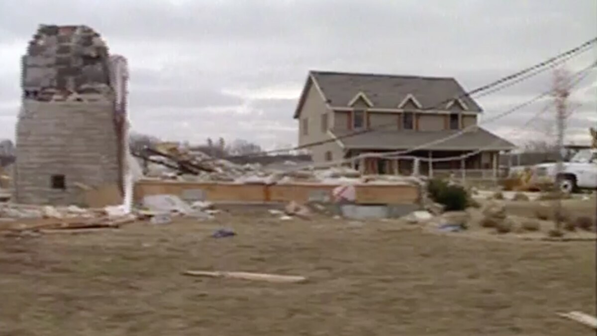
A storm summary partially taken from engineer and meteorologist Tim Marshall’s damage survey conducted a couple of days after the storm describes the damage path. The tornado struck an area from near Nixa to southeast Springfield, Missouri, causing F4 damage. Shortly after touchdown west of Nixa, the tornado reached F3 intensity, hitting a subdivision on the north side.
Continuing northeast while crossing Highway 65, the tornado picked up a truck and dropped it onto a frontage road, killing one passenger and injuring ten others. The tornado intensified to F4 strength as it moved through the Woodbridge and Natural Bridge Estates, subdivisions where 15 homes were destroyed. Altogether, two people were killed and 64 others were injured.
Marshall’s excellent tornado survey from the storm can still be found on a Reddit post taken from the StormTracker magazine publication back in 1992. Some eyewitness accounts indicate that the storm hit with little or no effective warning. A severe thunderstorm warning was issued but I could not find the text of a tornado warning.
A YouTube video of post storm coverage from KY3 shows some of the damage.
You can’t let your weather guard down, even late in the year. A variety of hazardous weather, from severe storms to winter weather can develop within less than a day, sometimes within hours. Today, we have more weather forecasts and better information technology at our disposal than ever before, but that doesn’t mean we are always prepared!