
It took a while to write this piece. Originally my focus was going to be on flooding and high-water safety with a focus on low-water crossings, and most of it is. However, it is hard to write about flooding when clouds of dust follow horses around in our pasture!
On the other hand, many have experienced plenty of recent rain, especially people south of Interstate Highway 44. So, let’s just call this an “odds and ends” weather piece.
The month of May started and ended dry at my house, with just a brief period of rainy weather in the middle. I’m glad about the rain we got. The U.S. Drought Monitor web page had the Springfield metropolitan region in abnormally dry conditions early in May, but the rains eased that slightly, at least briefly.
High pressure and (mostly) dry weather brought back drier soil conditions for some of us. Some humid weather with spotty showers and thunderstorms did finally occur to end the month of May. Forecast guidance for the next two weeks is a mixed bag (through June 14), but there is a hint of some rain at times, especially west of Springfield. We’ll see how it goes.
Personally, I’m hoping for more rain, but not too much. I know how fast Midwest weather can change. One good thing about the late May dry weather: I’ve seen lots of hay fields recently being cut, dried, and bailed.
More entrenched and serious true drought conditions exist not too far away from the Springfield area to the north and west, and there doesn’t look like any widespread heavier rain for the next few days. I’ve been told by more than one farmer that in the summer your next drought is always three weeks away. Well, for many north of I-44, that is easily already the case.

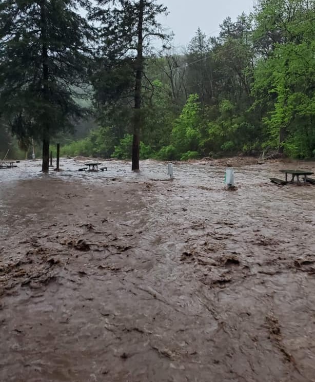
I found it a little unusual in May to see a pattern where weaker winds aloft allowed for slower less organized “multicell clusters” and “pulse” storms rather than more organized stronger storms. You can get severe weather with these types of storms, but in general, reports are more localized. Our new deck got a baptism by hail just days after completion on May 9. Other storms on May 15 brought isolated severe weather (and even a brief weak tornado in southern Dallas County). With abundant moisture/humidity, and slow-moving storms, excessive runoff and flooding resulted in a few low-water crossings being closed.
The Missouri Ozarks flooding and high-water hazards
May, June, and July mean more outdoor activities with school out. Boating, lazy floats down the creeks, camping, and fishing are all popular outdoor activities enjoyed in our area. This time also normally coincides with heavier rains and the potential for more frequent flooding. This means all the great outdoor activities can come with a higher-than-normal vulnerability where weather safety is concerned.
Even when rivers aren’t in flood, water flow rates are often faster than normal.
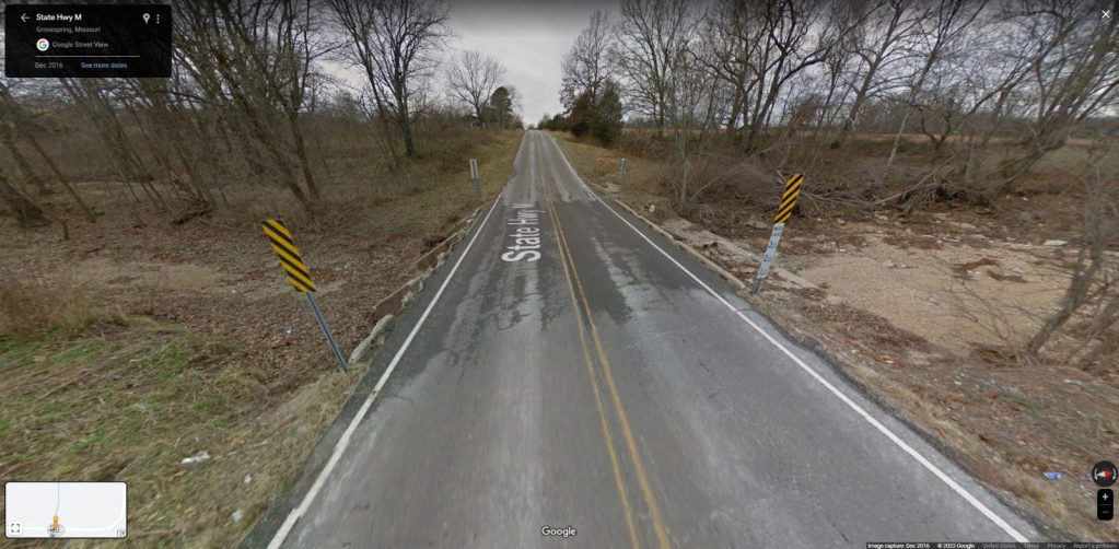
Low-water crossings: I had never heard of low-water crossings until I moved to Springfield in the mid-1990s.
When working at the National Weather Service, I can remember many times talking to dispatchers and emergency management during heavy rain situations. A typical question we would ask would simply be, “Do you have any flooding?” A not uncommon answer would be “It’s flooding in the usual spots.”
The answer was often given without a lot of concern. After all, flooding at these locations is frequent. Over time, I came to realize that sometimes it’s those “usual spots” that can get you into trouble, and they were almost always low-water crossings.
Heavy rain on March 23, 2023, produced the last incident of widespread flooding in the Missouri Ozarks along with three fatalities involving cars being swept off low-water crossings in Webster and Wright counties east of Springfield. Both of these incidents occurred in the evening, presumably with poor lighting and visibility when it is harder to recognize or see the dangers of the flooded roadway. Hilly terrain can also obstruct the hazard with poor line-of-site.
Why are there so many low-water crossings in the Missouri Ozarks?
The Ozarks is a hilly region with many small streams and rivers. Creek and small river valleys cut into the Missouri Ozark Plateau, which runs roughly from the Arkansas state line southwest of Cassville to the St. Francois Mountains in southeast Missouri. The terrain makes it difficult and expensive to build bridges over all the waterways and flood plains, so low-water crossings, in many cases, are more practical. This is especially true in flood plains that have little or no water flowing through them a vast majority of the time.
When heavy or torrential rain occurs in a creek basin upstream from a low-water crossing, a sudden “wall of water” can change a dry or low-flow creek bed into a raging flood in just minutes. The sudden flash flood makes it difficult to recognize the danger before it occurs. An example is Roaring River State Park where steep surrounding terrain can change the river flow very quickly.

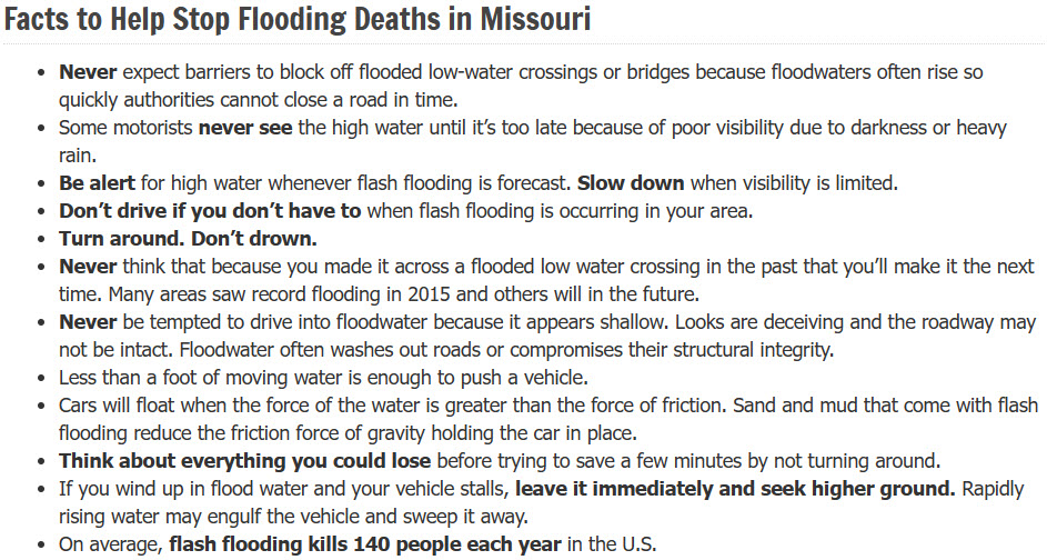
Low-Water Crossing Safety
The National Weather Service has worked closely with the Missouri Department of Transportation (MoDOT) and other agencies, and they list flood-vulnerable locations in their flood and flash flood warnings. There are also smartphone apps that have excellent radar and warning displays. As always, knowing the weather and hydrological conditions before you travel is a good practice. MoDOT has a traveler’s information map that displays road closures for state and federal interstate highways.
The Missouri State Emergency Agency also has some good safety education information specifically geared toward low-water crossing safety.
Next Month
I will feature comments and questions in future articles. Future ideas: I’m thinking of featuring what smartphone apps or websites you like to use to follow the local weather. Please send your email to DrewAlbert@protomail.com. Have a great month.