
The earth has reawakened and, at last, is greening up. As wildflowers bloom and ferns uncurl, our Ozarks streams are flowing again thanks to welcome rains.
And rain means spring waterfalls!
Hiking to waterfalls is my favorite way to get outdoors when temperatures warm. Watching an Ozarks stream tumble over rocks and bluffs amidst budding trees and wildflowers is a rejuvenating experience. Tall falls, low falls, dam falls, off-the-road falls, hike-to-see falls, family-friendly falls — waterfalls are plentiful around the Ozarks.
While many hide deep within the wilderness, plenty of waterfalls are easy to reach for folks who don’t hike and for families with kids.
If that’s you, bookmark this handy roundup.
This guide features nine waterfalls you can practically (or actually!) see from the road or parking lot. Yet all of these waterfalls have nearby trails to explore, too, making a nice day out.
Ready to celebrate the return of spring? Pick a waterfall and go!
Click here to view the list
Dam Falls, Devil’s Den State Park
Nearest town: Winslow, Arkansas
Distance from Springfield: 172 miles (2.5 to 2.75 hours)
GPS coordinates: 35.84466999628545, -94.2500546049083
Nearby natural attractions: Mulberry River, Natural Dam
Daily Citizen Guide: Yes, click here
While the Devil’s Den Trail in this Arkansas state park leads to Twin Falls, you won’t work that hard to see one of the park’s most popular points of interest, the Civilian Conservation Corps-built rock dam waterfall over Lee Creek. Tumbling from the park’s Lake Devil, you can see it from the parking lot. A very short walk takes you to the top of the rocky dam. More great spots to view the waterfall require some trail walking, but none of them are hard. This state park features so many adventures, it’s worth the drive for a weekend getaway.
Grand Falls
Nearest town: Joplin, Missouri — 5685 Riverside Dr.
Distance from Springfield: 74 miles (just more than an hour away)
GPS coordinates: 37.0328452079844, -94.540513047593
Nearby natural attractions: Shoal Creek, Inspiration Point and McClelland Park in Joplin
Daily Citizen Guide: No, but learn more here
Just an hour away on the outskirts of Joplin, the wide, roaring Grand Falls attracts locals and visitors alike. The largest continually running waterfall in Missouri, the waterfall on Shoal Creek drops 12 feet to a large pool below. Flowing over solid chert rock, the natural waterfall is backdropped by a constructed dam waterfall. You can easily see Grand Falls from a small parking lot on Riverside Drive, or get closer to the falls via a short dirt trail or by picking your way down the rocks. We saw families splashing in pools near the falls and about a dozen folks brought small remote-control trucks to crawl around the terrain.
Pinion Creek Falls
Nearest town: in Bella Vista, Arkansas
Distance from Springfield: 114 miles (1.75 hours)
GPS coordinates: 36.473786163187825, -94.23140734173964
Nearby natural attractions: Tanyard Creek Nature Trail and Falls, Blowing Springs Park
Daily Citizen Guide: No, but learn more here
This is another waterfall you can see from your car, although it’s also part of a two-mile trail. A gorgeous spot in Bella Vista near the “Back 40” mountain bike trails of Blowing Springs, it’s a short walk (depending on where you park along the road) to view from the bank of the creek or a bridge that goes over Pinion Creek. (Caution: The road continues past the waterfall onto private property.) This waterfall is about five minutes from the Tanyard Creek Nature Trail, an easy trail system that includes another waterfall.
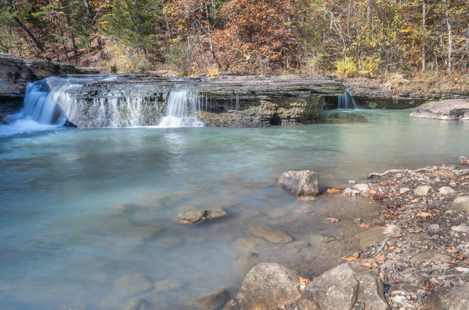
Rocky Falls
Nearest town: Eminence, Missouri
Distance from Springfield: 137 miles (2.3 hours)
GPS coordinates: 37.09494211900504, -91.21017064914034
Nearby natural attractions: Alley Spring Mill, Falling Spring
Daily Citizen Guide: Yes, click here
This tumbling rocky waterfall, created by shut-ins just 20 minutes southeast of Eminence, is easy to see with a short walk from the parking lot. The pool at the base of the waterfall is a popular swimming hole when the weather warms. Best of all, there are lots of other gorgeous natural places to visit nearby (see our guide).
Falling Spring Mill
Nearest town: Winona or Eminence, Missouri
Distance from Springfield: 139 miles (2.25 hours)
GPS coordinates: 36.86821409511994, -91.29509524348202
Nearby natural attractions: Rocky Falls, Alley Spring Mill
Daily Citizen Guide: Yes, click here
What makes this spot unique — and attractive to photographers — is the narrow stream of water falling from a bluff spring behind the mill. When the light is just right, the mill and spring make a beautiful reflection on the mill pond. The mill and falls — down a two-mile gravel road — can be seen from the parking lot and nearby picnic area.
Dam Falls, Mammoth Spring State Park
Nearest town: Mammoth Spring, Arkansas — 17 US-63, Mammoth Spring
Distance from Springfield: 138 miles (2.25 hours)
GPS coordinates: 36.496213294869435, -91.53388161690374
Nearby natural attractions: Spring River, Grand Gulf State Park, Missouri
Daily Citizen Guide: No, but learn more here
Mammoth Spring State Park, just south of the Missouri-Arkansas border and 15 minutes from Missouri’s Grand Gulf State Park, features a massive dam falls at the head of the Spring River. The dam falls can be seen from the parking lot, or take a very short trail to a bridge over the dam. This park also features a pretty spring lake and an easy trail to walk. With many more things to do in the area, it’s a lovely spot to visit.
Falling Water Falls
Nearest town: Ben Hur, Arkansas
Distance from Springfield: 137 miles (around 2.6 hours)
GPS coordinates: 35.72508, -92.94802
Nearby natural attractions: Six Finger Falls, Terry O’Keefe Falls, Intersection Falls, Fuzzy Butt Falls
Daily Citizen Guide: Yes, click here
You could sit in your car for a great view of this gorgeous 10-foot-tall shelf waterfall on Falling Water Creek. But, of course, you’ll want to get out! It’s easily viewed from the side of the road and unless the creek is rushing fast after rains, you may be able to walk out at the top of the falls. For those able to manage a short but steep hike down to its base, this waterfall is fun to explore and photograph. The pool at its base becomes a swimming hole in warm weather.
Six Finger Falls
Nearest town: Ben Hur, Arkansas
Distance from Springfield: 138 miles (2.66 hours)
GPS coordinates: 35.76193, -92.93753
Nearby natural attractions: Falling Water Falls, Terry O’Keefe Falls, Fuzzy Butt Falls, Intersection Falls
Daily Citizen Guide: Yes, click here
Roughly 3.6 miles from the roadside Falling Water Falls, Six Finger Falls is almost as easy to see except for a short albeit steep downhill path to reach it. While you can see the waterfall from the edge of the road, it’s worth the effort to get down to its base where kids can splash in the stream around it. This unique geologic wonder has six stair-step rock formation “fingers” creating waterfalls on Falling Water Creek. The location of Six Finger Falls is not marked, but we include detailed directions in this Daily Citizen guide, which also includes several easy hiking trails to more waterfalls in the area.
Haw Creek Falls
Nearest town: Between Pelsor and Hagarville, Arkansas
Distance from Springfield: 138 miles (2.5 hours)
GPS coordinates: 35.67689247126624, -93.25368607880199
Nearby natural attractions: Pam’s Grotto Falls, Long Pool Recreation Area, Richland Creek area, Pedestal Rocks Scenic Area
Daily Citizen Guide: No, but learn more here
A low-shelf waterfall roughly eight feet tall, the rocky bed of Haw Creek Falls is a lovely spot to picnic and ponder. About 100 yards from a small parking area near camping spots, the falls can be viewed down a short, easy, level path. If it’s been dry, you won’t see much water flowing but you can still explore the creek area. After visiting Haw Creek Falls, drive less than a mile up the creek to find another easy access to the water and, if you hike, the trailhead to Pam’s Grotto Falls.
Bonus: Enhanced waterfalls
It’s easy to find waterfalls at outdoor recreation centers developed by Johnny Morris of Bass Pro Shops. Dogwood Canyon, 2038 W. Missouri 86 in Lampe, is a fee-based outdoor park dotted with waterfalls tall and small along a 3-mile paved path through manicured outdoor spaces. Most waterfalls are enhanced so they are ever-beautiful and flowing. Find details about the park, about 60 miles from Springfield, on the Dogwood Canyon website.
You’ll also find enhanced waterfalls at Top of the Rock, the scenic visitor area that’s part of a golf course near Branson, 54 miles from Springfield. Visit the Top of the Rock website for more information.
Find more Daily Citizen outdoor guides
Natural outdoor areas are among our community’s greatest assets. That’s why the Daily Citizen features a rich array of Ozarks getaway and hiking guides — many with wonderful waterfalls. These guides — some of which are linked within this roundup — include map links, photos, way-finding information and details from first-hand experience to help readers know what to expect.
To find our list of guides, visit the Daily Citizen website and look for “Things to do” at the top. Select Springfield Area Guides from the drop-down menu. The best guides for waterfalls (or any outdoor adventure) are under “Nearby Roadtrip Destinations” and “Hiking Guides.”
Keep checking back: We add new guides most months.
Reminder: Bugs, snakes, ticks, slippery rocks and other hazards may be encountered in any wilderness area. Outdoor areas in this series are described from the firsthand experience of an average-ability hiker, however, readers must determine their own abilities.